Directions to Durban Avenue School
Address of Durban Avenue Elementary School: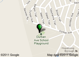
616 Durban Avenue
Hopatcong, NJ 07843
Durban Avenue Elementary School is located on Durban Avenue near the Animal Pound, just over the top of the hill.
From Rout 80 West
Take Route 80 West to Exit 28 (Ledgewood / Hopatcong). After exiting, road will fork, stay on your left (West Shore). At first traffic light (lake is in front of you) make a left on to Lakeside Boulevard.
Go to 3rd traffic light and make a left on to Brooklyn Mountain Road. Take Brooklyn Mountain Road (road will twist and turn) to first major intersection, that will be Durban Avenue. Make a left on to Durban Avenue. Go about 1/2 mile and school driveway is on the left.
From Route 10 West
Take Route 10 West to Ledgewood. Then follow Route 46 West. About 1/2 mile road will split (46 West will be on left) you stay to the right. Follow signs to Lake Hopatcong, West Shore. At first traffic light (lake is in front of you) make a left on to Lakeside Boulevard.
Go to 3rd traffic light and make a left on to Brooklyn Mountain Road. Take Brooklyn Mountain Road (road will twist and turn) to first major intersection, that will be Durban Avenue. Make a left on to Durban Avenue. Go about 1/2 mile and school driveway is on the left.
From Route 206 North
Take 206 North. Do NOT get on Route 80. Follow signs for Route 183. Go past Family Ford .Follow signs for 183 (go down ramp). You will be in Netcong. Stay on this road. Go past Lake Musconetcong and the Hess gas station on the right. Proceed to traffic light. At traffic light bear right onto Route 602 East Brooklyn-Stanhope Rd. Follow for about 1.8 miles and make a left onto Flora Avenue (see stone house on the corner). Follow Flora Avenue to the end. Make a left on to Durban Avenue. Go about 1/2 mile and school driveway is on the left.
From Hackettstown Area
Take Route 80 East to Exit 27 (Stanhope/Newton). Follow signs to Route 183. When road forks, stay left onto Route 183. At second traffic light (Linden Avenue) make a left. Go up small hill and make a right onto McKinley Avenue. At stop sign make a left onto 602 East.
You will pass a Lutheran Church on the right and a gas station on the left and about 1/2 mile up the road you will come to a very bad curve. At the 3rd street on the left after the curve (Flora Avenue) make a left (there will be a stone house on the corner).
Go to 1st stop sign and make a left on to Durban Avenue. School’s driveway will be about 1/2 mile up road on left.
From Route 206 South
Take Route 206 North to Route 287 North to Peapack Exit (back onto 206 North). Take 206 North to Netcong Circle. At Circle follow signs to 183 (Hopatcong State Park) At second light bear right (Brooklyn Stanhope Road) onto 602 East.
You will pass a Lutheran Church on the right and a gas station on the left and about 1/2 mile up the road you will come to a very bad curve. At the 3rd street on the left after the curve (Flora Avenue) make a left (there will be a stone house on the corner).
Go to 1st stop sign and make a left on to Durban Avenue. School’s driveway will be about 1/2 mile up road on left.
From New Jersey Turnpike
Take New Jersey Turnpike North to Exit 10 (which is 287). Follow signs to 287 North. Take 287 North to Peapack Exit (206 North). Take 206 North to Netcong Circle. At Circle follow signs to 183 (Hopatcong State Park) At second light bear right (Brooklyn Stanhope Road) onto 602 East.
You will pass a Lutheran Church on the right and a gas station on the left and about 1/2 mile up the road you will come to a very bad curve. At the 3rd street on the left after the curve (Flora Avenue) make a left (there will be a stone house on the corner).
Go to 1st stop sign and make a left on to Durban Avenue. School’s driveway will be about 1/2 mile up road on left.
